
Monday, September 17, 2012
Flooding possible today and Tuesday across portions of East Tennessee
Get the latest from here http://www.examiner.com/article/flooding-possible-today-and-tuesday-across-portions-of-east-tennessee
Thursday, September 6, 2012
Thursday, August 30, 2012
Isaac brings clouds and then rain for the weekend across East Tennessee
Today has started off with clouds across East Tennessee from now Tropical Storm Isaac..... Check out the Examiner for the rest here: http://www.examiner.com/article/isaac-brings-clouds-and-then-rain-for-the-weekend-across-east-tennessee?cid=db_articles
Thursday, August 23, 2012
Chances of storms on the increase for next week across East Tennessee
The drier conditions across East Tennessee continue today with surface high pressure in control. Today will be mostly sunny with highs in the upper 80s to lower 90s..... Read more here http://exm.nr/SY5i8O
Wednesday, August 22, 2012
The dry days continue....
Today will be another dry but warmer day across East Tennessee with high pressure in control. Highs will be in the mid to upper 80s. Thursday will be mostly sunny with highs in the upper 80s to lower 90s. The moisture will begin returning as we go into Friday with slight chances of a popup storms across the higher terrain. Highs will be in the upper 80s to lower 90s. For the weekend expect mostly sunny skies with popup storms along the higher terrain. Highs will be in the upper 80s to lower 90s.
The big weather story continues to be Tropical Storm Isaac. Right now the storm is located just off the coasts of the Caribbean Islands. This storm is still forecast to impact the US by early next week. Right now the National Hurricane Center has it moving into the southern tip of Florida. Anyone traveling to areas in Florida or the East Coast early next week should continue to monitor this tropical system.
The big weather story continues to be Tropical Storm Isaac. Right now the storm is located just off the coasts of the Caribbean Islands. This storm is still forecast to impact the US by early next week. Right now the National Hurricane Center has it moving into the southern tip of Florida. Anyone traveling to areas in Florida or the East Coast early next week should continue to monitor this tropical system.
 |
| Hurricanecity.com Model Forecast Tracks for Tropical Storm Isaac |
Tuesday, August 21, 2012
Another Dry Day....
Well folks another dry day is in store for East Tennessee. Today expect mostly sunny skies with highs in the lower to mid 80s. Wednesday will bring mostly sunny skies once again with highs in the mid to upper 80s. Temperatures will warm as the week goes on with upper level trough moving east and ridge building into the area. This will also bring the return of moisture as we go into Friday. Chances of precipitation will be low with mainly isolated afternoon showers and thunderstorms going into the weekend. Most of these will be in the higher terrain. The more interesting weather will be in the tropics where Tropical Depression Nine will continue to strengthen.
This system is forecast to become a hurricane by early Thursday morning. The ensemble GFS model shows this storm could affect the US by early next week. So if you have plans along the east coast you should monitor this tropical system as it could affect your plans.
 |
| National Hurricane Center Watch/Warning and Forecast |
 |
| Weather Underground ensemble GFS model plots |
Monday, August 20, 2012
Sunny Week Ahead....
Once again will be a quick forecast this morning. Does look like we will have much drier conditions across East Tennessee this week. Today expect mostly sunny skies and highs in the lower to mid 80. Tomorrow same with highs in the lower to mid 80. Conditions should stay sunny most of the week with highs in the mid to upper 80. I will resume normal forecasting tomorrow. I hope you have a great day. I leave you with a view from Bush Stadium.


Saturday, August 18, 2012
Clearing Today....
Will be out of the area for the weekend so updates will be quick. Today started off with a few scatter showers. I expect clearing out the afternoon with highs in the lower to mid 80s. Tomorrow clouds return with highs in the lower to mid 80s. Showers are possible going into Monday.
Friday, August 17, 2012
Storm This Afternoon....
Updating on the road this morning. Most areas starting off with clouds left over from storms that affected Nashville last night. I expect a active weather day across East Tennessee as the frontal boundary and upper level trough move through the region. The SPC still has all of East Tennessee in a slight risk today. Main threat will be damaging winds and heavy rain. Today will see highs in the lower to mid 80s. Clearing some for the weekend with highs in the lower to mid 80s. Will try to have a update later this afternoon. Stay safe out there.

Thursday, August 16, 2012
Fog To Start....
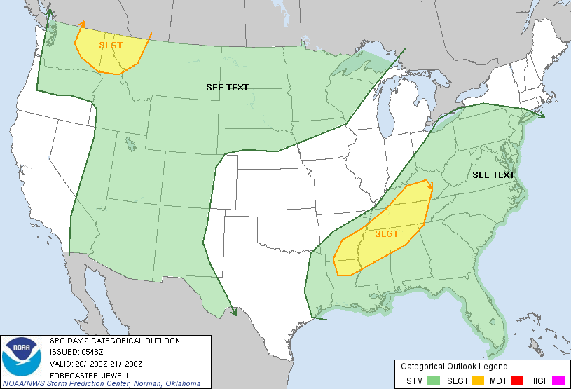
Some areas are seeing some fog to start the day with temperatures in the in the lower 60 to upper 60s. I expect fog to clear and mostly sunny skies to prevail. Highs will be in the upper 80s to lower 90s. Tomorrow will be the more interesting weather day as cold front and strong upper level trough move to the east. This will give way to good chances of showers and thunderstorms in the afternoon with highs in the mid to upper 80s. The Storm Prediction Center has issued a slight risk over all of Eastern Tennessee for Friday.
The main risk will be strong winds and heavy rain. Saturday expect some clearing with partly cloudy skies and highs in the lower to mid 80s. Sunday there is some disagreement with chances of showers in the models. Right now will go with a chance of showers and highs in the lower to mid 80s. We clear out into early next week with highs in the lower to mid 80s.
 |
| SPC Day 2 Convective Outlook for Friday at 8AM to Saturday at 8 AM EDT |
Wednesday, August 15, 2012
Light Rain To Start....
Some areas are seeing some showers this morning as upper level disturbance and frontal system finally make there way through and out of the region.
I do expect some clearing later today with highs in the lower to mid 80s depending on cloud cover. Tomorrow will be warm with mostly sunny skies and highs in the upper 80s to lower 90s. A unseasonably strong upper level trough will begin affecting the area going into Friday.
This will bring good chances of showers and thunderstorms as frontal boundary moves into the area. Right now it does look like the severe threat will be low, but can't rule out isolated severe threat. The weekend will see partly sunny skies and highs in the lower to mid 80s. Clearing out going into early next week with highs forecast to be in the low to mid 80s.
 |
| GRLevel 2 Radar at 9:10 AM EDT/ Frontal Analysis at 5 AM EDT |
 |
| NCEP 500mb Height/Wind/Vorticity for Friday at 2 PM EDT as modeled by NAM on Left and GFS on right |
Tuesday, August 14, 2012
Starting Off With Showers And Storms....
Some Areas are starting off with some showers and thunderstorms this morning including Knoxville with temperatures in the mid to upper 60s.
Today I expect showers and thunderstorms will be possible this afternoon with approaching frontal boundary. The chances of strong to severe storms is low, but possible as instability is forecast to be in the 1000 g/kg range. Main threat would be isolated strong wind. Highs will be in the lower to mid 80s. Tomorrow expect mostly to partly cloudy skies with highs in the mid to upper 80s. Thursday will be partly cloudy with highs in the upper 80s. Next best chance of Precipitation will be going into Friday and Early Saturday as yet another frontal boundary and associated upper level wave move through the region.
 |
| GRLevel 2 Radar at 8:02 AM EDT/Frontal Analysis at 5 AM EDT |
Monday, August 13, 2012
Chances Of Rain Return....
Starting off the morning in the lower 60s across much of the area with Tri-Cities the cooler spot in the upper 50s. I hope you enjoyed a beautiful weekend with highs in the lower to mid 80s and Clear skies. Today should be another nice day with mostly sunny skies and highs in the mid to upper 80s. I expect clouds to move in later tonight with chances of showers and storms late. Tomorrow showers and storms possible in the early morning and then more showers and storms possible later in the afternoon. This activity will be kicked off by a cold front that is approaching the region.
Some of the storms later tomorrow could be strong with strong wind and heavy rain. Weather clears up for Wednesday with mostly sunny skies and highs in the mid to upper 80s. Next chances of precipitation will be late Friday into Saturday as yet another cold front moves through the region. This is a active pattern for August with multiple longwave troughs moving through the region.
 |
| SimuAWIPS Frontal Analysis for Early Monday |
Saturday, August 11, 2012
Dry And Cooler Day....
Starting off the morning for most areas in the upper 60s with cloud cover. Expect a great day ahead with frontal boundary southeast of the area mostly sunny skies will prevail. Highs will be in the lower to mid 80s.
Continued dry tomorrow with mostly sunny skies and highs a touch warmer in the mid to upper 80s. Another frontal boundary will approach the area late Monday night into Tuesday bringing chances of showers and thunderstorms. Slight chances for Wednesday into Thursday and another trough and frontal boundary moves into the region for Friday.
I expect highs Monday through Thursday in the mid to upper 80s for the Valley and Northeast Tennessee and upper 80s to lower 90s for the Southern Valley.
 |
| SimuAWIPS Frontal Position at 6:30 AM EDT and Visible Satellite at 9:05 AM EDT |
 |
| SimuAWIPS GFS 500mb Height/Wind For Friday Aug. 17 at 2 PM EDT |
I expect highs Monday through Thursday in the mid to upper 80s for the Valley and Northeast Tennessee and upper 80s to lower 90s for the Southern Valley.
Friday, August 10, 2012
Starting Off With Showers....
Good morning folks we are starting off with a few pre-frontal showers this morning. Quite a few areas will be getting wet with showers stretching across all of East Tennessee.
I expect as the front approaches and moves through the region we will have better chances of showers and thunderstorms this afternoon. The big question this morning is will the atmosphere recover from this morning and yesterday. Right now I think we will have enough to produce some strong to possibly severe storms this afternoon with heavy rains and wind being the biggest impact. The timing on this should be this afternoon around 2 to 3 PM. Highs will be in the lower to mid 80s with cloud cover and precip. Tomorrow I expect much drier and cooler conditions with some cloud cover. Highs will be in the lower to mid 80s. Sunday mostly sunny and drier with highs in the mid to upper 80s. Chances of precipitation return for Tuesday along with dewpoints back in the 60s.
 |
| GRLevel 2 Radar at 8:21 AM EDT |
Thursday, August 9, 2012
Quick Forecast Update....
Due to some work this morning I was unable to send out the regular forecast. We do have ongoing storms at this time with some severe. Expect this line of storms to push through the area over the next few hours. Good chances of storms will exist tomorrow with best chance being around 12 to 5 PM. Some of these storms could be strong with highs in the lower to mid 80s. Clearing out for Saturday with highs in the lower to mid 80s. Remember to follow on Facebook or Twitter for the latest on the severe weather coming through the area.
Wednesday, August 8, 2012
Slight Chances Of Storms....
Some areas have started off with some fog. All areas are dry as far as precipitation goes this morning with partly cloudy skies. Temperatures this morning are in the lower to mid 70s.
Frontal Boundary will push south of the area today with slight chances of afternoon storms in the higher terrain. Highs will be in the lower to mid 90s. Tomorrow expect increasing chances of storms mainly in the afternoon with highs in the lower 90s. Good chances for morning and afternoon storms on Friday. Highs will be in the mid 80s. Timing on this system will be tricky with pre-frontal storms early and later the frontal boundary moves through the region. The NAM is indicating frontal boundary to begin affecting the Plateau around 2 PM and the rest of the Valley at 5 PM. Main threat for Friday will be high winds. Then get ready for a nice weekend with skies clearing out. Temperatures will be in the lower 60s for lows and highs in the mid to upper 80s.
 |
| SimuAWIPS Visible Satellite at 9 AM EDT |
 |
| SimuAWIPS Surface Temperature and MSL pressure at 5 PM Saturday |
Tuesday, August 7, 2012
Storms To Start....
Radar is indicating a few showers and thunderstorms across the area this morning. This is associated with the pesky frontal boundary that has been affecting the region over the past few days.
Showers and thunderstorms will be possible through the day with the aforementioned boundary. Highs will be in the mid to upper 80s. Tomorrow expect a drier day with only a slight chance of a storm in the higher terrain. Highs will be in the lower 90s. Thursday expect a increased chances of showers and thunderstorms with approaching cold front and upper level trough. Friday expect frontal boundary to move through the region giving way to showers and thunderstorms with highs in the mid to upper 80s. This system is forecast to be one of the stronger upper level systems we have seen in quiet some time. This system could cause some severe weather and I will be monitoring the possibilities across the area over the next few days.
This high amplitude system will carve out the summer temperatures for the weekend with highs in the lower to mid 80s.
 |
| GRLevel 2 Base Reflectivity at 9:26 AM EDT |
 |
| SimuAWIPS NAM:left/GFS:right Comparison for Friday at 18Z/2 PM EDT |
Monday, August 6, 2012
Another Wet One....
Another wet day will be possible across much of the area. There is already some showers that have already formed out ahead of the boundary this morning. The heavy rains from yesterday have also prompted a Flash Flood Watch across parts of the area.
I expect more showers and storms to fire later today as quasi-stationary frontal boundary moves through the region later tonight into Tuesday. highs today in the lower to mid 80s depending on cloud cover and precipitation. Tuesday chances of showers and storms mainly in the higher terrain and Northeast Tennessee. highs in the mid to upper 80s. Wednesday will dry out some with partly cloudy skies and highs in the upper 80s to lower 90s. Storm chances increase going into Thursday and Friday as another frontal boundary is forecast to approach the area with highs in the mid to upper 80s.
 |
| SimuAWIPS Regional Radar for 8:55 AM EDT |
 |
| Watch/Warning Map at 9:03 AM |
Sunday, August 5, 2012
Stormy Day....
Showers and thunderstorms will mainly affect the Northern Plateau and Valley as well as Northeast Tennessee this morning.
These storms are not severe and are left over from storms that affecting parts of Missouri. I expect as the cold front continue to move east that we will see more showers and thunderstorms as the day goes on. This has prompted a slight risk across the area with main threat being damaging wind and heavy rain with precipitable water values being on the 2 inch range this afternoon.
The area will see good chances of storms tonight through tomorrow as frontal boundary slowly moves through the area. Highs should be in the mid to upper 80s with cloud cover and storms. This weak front will not cool or clear out the moist and unstable air mass, so will keep a chance of showers and thunderstorms most of the week with a increase chance for Thursday. Highs will be in the upper 80s to lower 90s.
 |
| SimuAWIPS Radar at 9:15 |
 |
| SPC Day 1 Convective Outlook for 9 AM today till 8 AM Monday |
Saturday, August 4, 2012
Showers And Thunderstorms....
 |
| SimuAWIPS 500mb heights/wind |
 |
| SPC Day 2 Convective Outlook for 8AM Sunday to 8AM Monday |
Friday, August 3, 2012
Showers And Storms Likely....
Starting off the morning in the mid to upper 70s across most areas with the usual cool spot in the Tri-cities where temperatures are in the upper 60s. Areas are seeing cloud cover with approaching upper level trough. This will give us a likely chance of showers and thunderstorms. The timing is not in sync with the NAM and RAP models, but based on location of precipitation and better verification with RAP will go with around lunch time.
Highs today should be in the mid to upper 80s depending on cloud cover and precipitation. Tomorrow expect good chance of storms with highs in the mid to upper 80s. Sunday much the same with chances of storms and highs in the mid to upper 80s. Looking at the long range does look like could have precipitation chances continuing for Monday, and possibly some clearing by Wednesday high temperatures in the upper 80s to lower 90s.
 |
| SimuAWIPS Base Reflectivity at 8:45 AM EDT |
Wednesday, August 1, 2012
Storms Possible....
Most areas starting off in the mid to upper 60s this morning with Chattanooga the warm spot in the lower 70s. Areas of fog will affect travel for the next few hours with visibilities possibly 1 or 2 miles depending on the area. Northwest flow aloft will continue across East Tennessee with a weak front to the north.
Today showers and thunderstorms will be possible with focus point being the Plateau. Some of these storms could move through the Valley as the afternoon goes on. Highs will be in the upper 80s to lower 90s. Thursday expect drier day with highs in the upper 80s to lower 90s. Friday increase chances of storms as short wave approaches the area with highs in the upper 80s to lower 90s.
 |
| SimuAWIPS 500 mb Flow/Frontal Analysis/Water Vapor Satellite |
 |
| SimuAWIPS 500 mb Winds/Heights for Friday at 2 PM EDT |
Tuesday, July 31, 2012
Early Storms....
Showers and thunderstorms have started off your day in parts of the area. Heaviest area of showers and thunderstorms remained in the Southern Valley with some more scattered activity for the Central Valley. Northeast Tennessee remains mostly dry this morning as expected. Temperatures are in the upper 60s to lower 70s across most areas this morning.
Rest of today will be clearing out with slight chances of afternoon storms highs in the upper 80s to lower 90s. Tomorrow expect slight chances of storms mainly on the higher terrain with highs in the lower 90s. Warm day for Thursday with storms chances increasing slightly still mainly higher terrain activity with highs in the lower to mid 90s. Increase chances of precipitation for Friday through the weekend with highs in the lower 90s.
 |
| GRLevel 2 Base Reflectivity at 8:23 AM EDT |
Monday, July 30, 2012
Update....
After looking at the model data that came out this morning it does look like the MCS will begin moving into the area in the early morning hours between 2 AM and 5 AM EDT. The same holds true as it did in my forecast this morning the best chances will be in the Southern Valley near Chattanooga with less chances in Northeast Tennessee toward Johnson City. The Storm Prediction Center has also nudged slight risk south with far Southern Valley including Chattanooga still in the risk area. I will continue to monitor as system develops.
Chances Of Storms On The Increase....
Most locations are in the upper 60s to lower 70s this morning with a little bit of cloud cover in some locations. The trough that has been affecting the weather over the past week will continue to be the dominate feature across the Eastern US. Today I expect mostly dry day with some chances of storms across the higher terrain and Northeast Tennessee. High temperatures will be in the lower 90s. Overnight and tomorrow increase chances of showers and thunderstorms will be possible with MCS moving close to the region. Best chances of storms look to be in Southern Valley with lower chances across Northeast Tennessee. Models do have a hard time with these types of systems, so I will have to monitor for changes. This has prompted a slight risk for severe storms for tomorrow across the area.
For your Wednesday expect chances of storms mainly on the higher terrain. Highs for the week should stay in the lower 90s.
 |
| Day 2 Convective Outlook for 07/31/12 at 8 AM EDT to 08/01/12 at 8 AM EDT |
Saturday, July 28, 2012
Slight Chance Of Storms....
Starting off some what cooler across the area this morning with temperatures in the lower 70s across most areas. Frontal system that has been the focus for weather over the past several days is still to our north.
There could be a slight chance of storms as boundary rolls through the area with highs in the lower 90s. Right now looking at a sunny day for Sunday with highs in the lower 90s. Slight chances of storms return Monday with highs staying in the 90s. Best chances of storms return for your Tuesday and Wednesday. Highs will stay in the lower 90s.
 |
| SimuAWIPS frontal analysis at 6:40 AM/Radar at 7:45 AM |
Friday, July 27, 2012
Storms Possible....
Well starting off mild with temperatures across the area in the upper 70s to lower 80s. The quasi-stationary frontal boundary that aided in the development of storms that caused all the wind damage from Connecticut down to Texas is still west of the Tennessee this morning.
I do expect as frontal boundary continues to approach the region some showers and thunderstorms will form out ahead of the main boundary. The question this morning is how much will the atmosphere be able to recover in order to get development across East Tennessee. Right now NAM, RAP, and WRF models are indicating storms moving into the Valley around 2 PM and the HRRR shows some activity at 2 PM with more through 5 PM. Expecting marginal instability but weaker upper level support, so little in the way of severe weather today. Main threat with these storms will continue to be damaging winds with stronger storms. I will continue to monitor throughout the day for development. Tomorrow will be drier as weak boundary moves through the area with highs in the lower 90s. The biggest affect from the frontal boundary will be the drier nights with lows getting back into the upper 60s. Sunday another drier day with highs in the lower 90s. Chances of storms increase Monday through Wednesday with best chance right now Wednesday.
 |
| SimuAWIPS Frontal Analysis 6:30 AM/Radar at 8:55 AM |
Thursday, July 26, 2012
Another Hot One....
Staring off the morning with some fog across the higher terrain and Northeast Tennessee. Temperatures across the region are generally in the upper 70s with the cool spot being the Tri-Cities in the lower 70s.
Low chances of any storms today with highs in the mid to upper 90s across the region. The main impact today will be the hot temperatures coupled with dewpoints in the upper 60s to lower 70s. This will allow heat indices in the 100s. Showers and storms out ahead of impending cold front will be possible across the area in the early morning hours tomorrow. The best chances of showers and thunderstorms will be tomorrow afternoon around 2 to 5 PM.
Saturday afternoon cold front will finally pass through the area. Some relief in temperatures expected with highs in the lower 90s. Watching another complex of storms that develops across the upper plains early Saturday and is modeled to approach the region late Sunday. The models sometimes have a hard time handling this, but the NAM model has been consistent in showing this system moving toward the region.
 |
| SimuAWIPS Visible Satellite/Surface Fronts |
 |
| SimuAWIPS NAM 06Z Composite Radar for Friday 07/27/12 at 2 PM |
Wednesday, July 25, 2012
Isolated Storms....
Starting off the morning with some rain and storms across Northeast Tennessee. The main area of rain has moved south with a few showers possibly moving into the area from Eastern Kentucky.
Most of East Tennessee is dry this morning but mild with temperatures in the upper 70s and the rain cooled spot Tri-Cities in the upper 60s. Expect a summer like setup today with storms firing up mainly across the higher terrain. Some of the storms could drift into the Valley with heavy rain being the main threat. The heat will also be a factor today with temperatures expected to get into the mid to upper 90s. These temperatures coupled with dewpoints in the lower 70 will make for high heat indices in the upper 90s to 100s. Make sure to take breaks when outside and drink plenty of fluids. Another similar day for Thursday with isolated storms possible and high in the mid to upper 90s. Again high heat indices possible as warm moist air moves north ahead of the cold front. Best chances of rain will be Friday with timing looking to be early afternoon right now. Clearing for the weekend with highs in the lower 90s.
 |
| SimuAWIPS Radar at 8:55 AM |
Tuesday, July 24, 2012
Thunderstorms With Some Strong....
Most areas starting off in the mid to upper 70s with the cool spot being the Tri-Cities in the lower 70s. The story today is we are monitoring a thunderstorm complex that has setup over the Ohio Valley this morning.
This complex has the capability of producing damaging winds and heavy rain. Currently the timing of this complex is at question with RAP model indicating later this afternoon and NAM model later tonight.
Models due conflict with these complexes sometimes and will need to see next run of the NAM coming out by early afternoon. Currently going to go with the RAP and expect showers and thunderstorms complex to come in later this afternoon. It does look like storms are forming south so we could some storms earlier ahead of complex.
Tomorrow expect chances of afternoon thunderstorms with highs in the mid 90s. Another warm day on tap for Thursday with highs in the mid to upper 90s. It will be hot and sticky as dewpoints will be in the lower 70s. Friday another good chance of storms as frontal boundary approaches the area. Temperatures for the weekend make it back into the upper 80s to lower 90s.
 |
| SimuAWIPS Radar 8:45 AM/Fronts 6:40 AM |
 |
| SimuAWIPS Left RAP at 6 PM and Right NAM at 11 PM |
 |
| SimuAWIPS Radar at 9:05 AM |
This system has prompted a Slight risk across the area with damaging winds being the main threat.
 |
| SPC Day 1 Convective Outlook |
Monday, July 23, 2012
Isolated Storms....
This morning we are starting off with partly to mostly cloudy skies with a few areas of fog. Dominate feature is the upper level ridge aloft.
Today will be another day of possible storms mostly in the afternoon and higher terrain. Although hopefully it will be a bust like yesterday with main areas of storms in Eastern Kentucky and Southwest Virginia. The storms we do get will most likely produce heavy rains. I expect temperatures in the lower 90s depending on storms. Tomorrow chances of afternoon storms will exist with highs again in the lower 90s. The better chance of precipitation that was forecasted for Wednesday may not happen. This mainly due to frontal boundary staying farther north. It does look like a frontal boundary will move into the area by weeks end giving way to better chances of precipitation. The big story till then will be the increase in heat across the region as temperatures for Thursday are expected to get back into the mid to upper 90s. That coupled with high moisture will produce higher heat indices and make it feel much warmer.
 |
| SimuAWIPS 500mb Height and Wind/Water Vapor Satellite |
Sunday, July 22, 2012
Slight Chances Of Storms....
A few showers are affecting Northeast Tennessee this morning and will continue to move to the east out of the region.
Today will be similar to yesterday with chances of pulse storms across the region. Mainly affecting the mountains with some making it to the Valley. Expect highs to be in the upper 80s to lower 90s depending on storms. For your work week expect continued chances of showers and thunderstorms. The better coverage of storms will be Tuesday and Wednesday as upper level trough begins to dig farther south.
 |
| SimuAWIPS Radar 7:45 AM EDT/Front 6:30 AM EDT |
Today will be similar to yesterday with chances of pulse storms across the region. Mainly affecting the mountains with some making it to the Valley. Expect highs to be in the upper 80s to lower 90s depending on storms. For your work week expect continued chances of showers and thunderstorms. The better coverage of storms will be Tuesday and Wednesday as upper level trough begins to dig farther south.
 |
| SimuAWIPS 500mb heights/wind for Tuesday at 5 PM EDT |
Saturday, July 21, 2012
Front Finally South....
The frontal boundary has finally moved south of the area this morning as seen by surface analysis.
Along with frontal boundary moving south, the upper level trough over the east coast that has affect our weather will begin to flatten out allowing the upper level high to control our weather again.
Today expect possible afternoon showers and storms mainly in the higher terrain with highs in the upper 80s to lower 90s. For tomorrow expect chances of storms once again mainly on the higher terrain with highs in the upper 80s to lower 90s. The main threat this week will be afternoon showers and thunderstorms along with possibility of MCS storms systems to move south toward East Tennessee. Best chances still appear to be Wednesday. Highs will continue to be in the lower 90s depending on cloud cover.
 |
| SimuAWIPS Surface Analysis 6:20 AM/IR Sat 7:05 AM |
 |
| SimuAWIPS 500mb height and wind for 7 AM to 7 PM |
Friday, July 20, 2012
Stormy....
Surface analysis from HPC indicates weak frontal boundary still parked north of the area along the northern Kentucky border.
As this front moves south expect more storms to fire out ahead of this boundary. The big factor here will be how much can we recover after storms last night. We still have left over showers and few embedded storms mainly along the Plateau and Southern Valley.
The main threat today will be heavy rains and strong wind. I will continue to monitor changes as morning and afternoon goes on. Saturday expect chances of afternoon showers and thunderstorms with highs in the upper 80s. The forecast for Sunday does look drier, but will have to monitor as upper level high shifts east will see possibility of storms systems rotating around the high. Expect temperatures to return to the lower 90s going into the work week.
 |
| HPC Surface Analysis for 5 AM |
As this front moves south expect more storms to fire out ahead of this boundary. The big factor here will be how much can we recover after storms last night. We still have left over showers and few embedded storms mainly along the Plateau and Southern Valley.
 |
| GRLevel 2 Base Reflectivity at 8:43 AM EDT |
Thursday, July 19, 2012
More Showers And Thunderstorms....
Chances of showers and thunderstorms today with some upper level help swinging through the area. These disturbances will be weak so expect slow moving activity again today. Main impact will be heavy rain/flooding and lightning. Once again with plenty of moisture in place precipitable water values are around 1.6 to 1.9 this morning. Highs today will be in the upper 80s to lower 90s depending on cloud cover.
Still looking at tomorrow for best chances of storms with some being strong late in the day on Friday. The weak frontal boundary to the north coupled with short wave energy will be the focus for convection. Main severe weather threat right now is forecasted to be north and west of most of the area, but would not rule a a few severe storms in East Tennessee.
 |
| SPC MesoAnalysis Precipitable Water/Radar |
 |
| SPC Day 2 Convective Outlook 8AM Friday to 8AM Saturday |
Your weekend looks to be warm with more afternoon convection with higher terrain being the focal point. Highs for the weekend will be in the upper 80s to lower 90s. Chances of precipitation go down Sunday through Monday and increase by Wednesday.
Wednesday, July 18, 2012
Another Stormy Day....
Another stormy day with Southern Plateau and Valley starting off with showers and thunderstorms. This has prompted a urban and small streams advisory for Rhea County. I expect heavy rain to be main threat again today with precipitable water values starting off in the 1.5 to 2.0 inch range.
Expect chances of showers and thunderstorms to continue today with highs in the lower 90s depending on cloud cover. Remember greatest threat will be heavy rain and lightning. I expect better chances for tomorrow and Friday as weak frontal boundary and low move toward the region. I expect highs in the upper 80s to lower 90s depending on storms. This weekend expect chances of afternoon storms with highs in the lower 90s.
 |
| GRLevel 2 Base Reflectivity at 9:03 AM EDT |
 |
| SPC MesoAnalysis Precipitable Water and Radar |
Tuesday, July 17, 2012
Storms Have Developed....
Some storms have developed with the aid of deep moisture convergence, upper level disturbance and instability. Follow on Facebook page or Twitter for latest information.


 |
| GRLevel 2 Base Reflectivity at 11:52 AM EDT |


 |
| SPC MesoAnalysis Deep Moisture Convergence, 850 convergence/250 divergence, and Surface Based CAPE (Convective Available Potential Energy) |
Subscribe to:
Comments (Atom)